Geology of the Serra da Arrabida
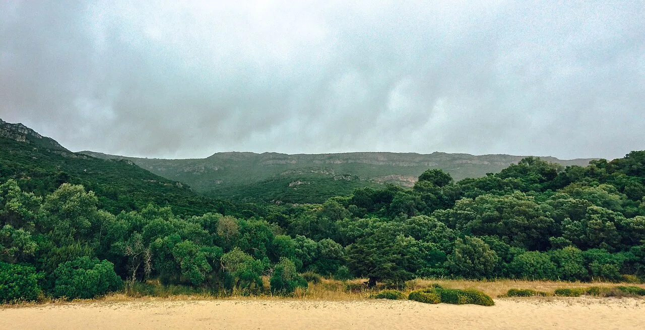
The Serra da Arrabida is a mountain range on the Setubal Peninsula of outstanding geological interest. Its limestone rocks from the Mesozoic Era (Jurassic and Cretaceous periods) preserve the memory of ancient tropical seas that covered this territory hundreds of millions of years ago. Karst processes have carved more than a hundred caves and grottos here, while palaeontological finds – including dinosaur tracks – connect the geological history of the region with the global processes that shaped the Earth.
Geological history
The Mesozoic Era: birth of the limestones
During the Mesozoic Era (252–66 million years ago) the territory of the modern Setubal Peninsula was covered by shallow tropical seas. It was during this period that the principal rocks of the Arrabida were formed.
Jurassic Period (201–145 million years ago): For a substantial part of the Jurassic, the Arrabida area constituted a marine ecosystem submerged beneath the ocean. In warm, shallow seas, carbonate sediments accumulated – the shells of molluscs, corals, foraminifera and other marine fauna. These sediments gradually transformed into dolomitic limestones – white carbonate rocks that today form the backbone of the mountain range.
At the end of the Jurassic (Upper Oxfordian, ~160 million years ago), a widespread emersion event and karst processes produced the celebrated Arrabida Breccia (Brecha da Arrabida) – a unique intraformational conglomerate breccia of carbonate clasts in various shades, bound by a carbonate-red clay cement. Historically misnamed “Arrabida marble” (marmore da Arrabida), this stone is in fact an Upper Jurassic conglomerate breccia.
Cretaceous Period (145–66 million years ago): During this period the territory subsided, producing alternating layers of limestone, sandstone and marl.
Tectonics: collision of continents
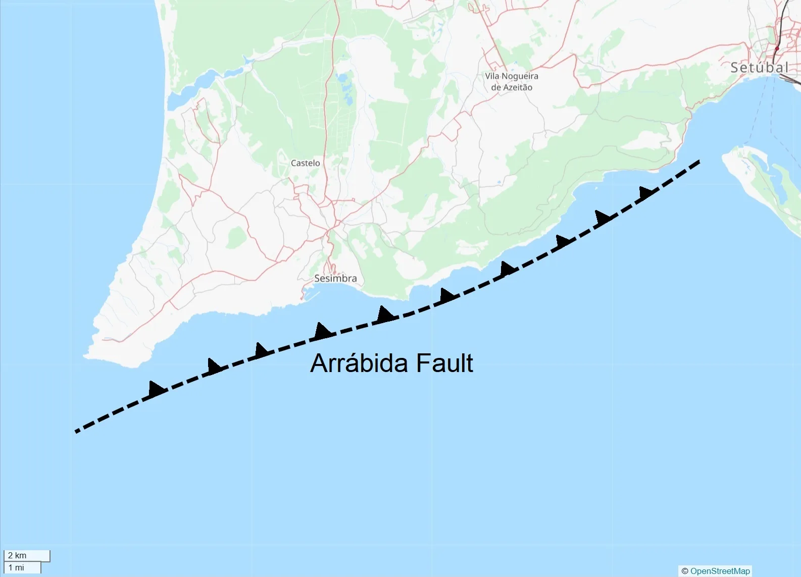
The geological uniqueness of the Arrabida is linked to its position at the boundary between two lithospheric plates – the African and the Eurasian. The collision of these plates, which began in the Late Cretaceous, led to:
- The uplift of the seabed and the formation of the mountain ridge
- Folding and faulting in the limestone strata
- The shaping of the present-day relief with its characteristically precipitous cliffs along the southern slope
The Serra da Arrabida is a unique territory on the Atlantic coast of Europe, demonstrating the westward extent of the Tethys Sea and the formation of the Mediterranean as a result of the African-Eurasian plate collision. This makes the mountain range a natural geological laboratory of global significance.
Formation of the present-day relief
The Serra da Arrabida reaches a maximum elevation of 501 m (the summit of Formosinho). The southern flank of the range drops to the ocean in sheer cliffs – the Serra do Risco, rising to 381 m at its peak (the Pincaro), constitutes the highest sea cliff in continental Europe.
The characteristic landscape includes:
- White limestone cliffs and escarpments
- Deep gorges and canyons
- Karst sinkholes and dolines
- Caves and grottos of varying size
Karst phenomena
The mechanism of karstification
The limestones of the Arrabida are subject to chemical weathering – karst processes. Rainwater saturated with carbon dioxide slowly dissolves the carbonate rock, creating distinctive landforms:
- Surface karst: karren (lapiez), sinkholes, ponors
- Subsurface karst: caves, grottos, underground galleries, stalactites and stalagmites
The caves of the Arrabida
The mountain range contains more than 100 caves, grottos and underground cavities, making it one of the most speleologically rich areas in Portugal.
Gruta do Frade (Cave of the Friar)
The best-known cave in the Arrabida is the Gruta do Frade (Cave of the Friar), discovered in May 1996 by the Costa Azul Speleology Centre (NECA) during a coastal survey. It is the largest and most complex underground cavity in the Serra da Arrabida:
- Length: 340 m linear, 40 m width
- Location: at sea level, in the Recha d’Arcos cliff
- Speleothems: approximately 40 classified types of lithochemical formations
- A horizontal system of galleries and conduits coinciding with a phreatic zone
- The geological complex was formed during the Jurassic (180–160 million years ago)
The cave is not open to the general public, in order to preserve its fragile subterranean ecosystems. Access is difficult owing to atmospheric conditions, waves and tide levels.
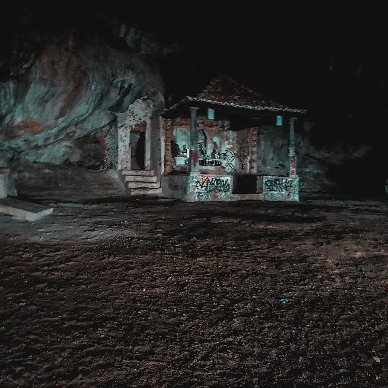
Lapa de Santa Margarida
Lapa de Santa Margarida is a small chapel, [DISPUTED] variously dated to the 17th or 18th century, concealed within a picturesque sea grotto near Portinho da Arrabida. Access is by a steep, winding path of roughly 200 stone steps descending through limestone cliffs to the grotto at sea level.
Inside the natural cavern, which opens directly onto the ocean, stands a simple whitewashed chapel with a small altar. The site is a remarkable example of the symbiosis of geology, nature and religious tradition.
Other notable cavities
- Gruta da Furada – a cave with a through-passage
- Numerous small grottos along the southern coast, historically used by fishermen as shelters
- Sea caves at the base of the cliffs, accessible only from the water
Palaeontological significance
Fossil fauna
The limestone rocks of the Arrabida contain abundant fossil remains from the Mesozoic Era:
- Fragments of dinosaur bones, predominantly sauropods (large herbivorous dinosaurs)
- Fossilised ammonite shells and other molluscs
- Traces of Jurassic marine fauna
Dinosaur tracks
In the Setubal Peninsula region, at Cabo Espichel (Cape Espichel), two complexes of dinosaur tracks have been discovered:
- Pedra da Mua – Late Jurassic tracks, including sauropod and theropod footprints. Seven parallel sauropod trackways attest to gregarious behaviour in these animals.
- Jazida dos Lagosteiros – Early Cretaceous tracks (Lower Barremian, ~130 million years ago), the only example of Cretaceous dinosaur footprints in Portugal. Theropod and ornithopod prints have been identified here.
The two sites lie only 500 m apart but are separated in time by approximately 50 million years. Although Espichel lies to the west of the Arrabida, both areas belong to the same geological formation and share a common palaeontological history.
Rocks and minerals
Principal rock types
| Rock | Period | Characteristics |
|---|---|---|
| Dolomitic limestone | Jurassic | White; forms the backbone of the mountain range |
| Sandstone | Cretaceous | Alternates with limestones |
| Sedimentary breccia (Arrabida Breccia) | Upper Jurassic | Decorative stone, IUGS World Heritage Stone |
| Marl | Various | A mixture of limestone and clay |
Arrabida Breccia
The sedimentary breccia of the Arrabida (Brecha da Arrabida), historically known by various names – “Jasper Stone”, “Ancient Red”, “Arrabida mosaic marble” – is an Upper Jurassic (~160 million years old) intraformational conglomerate of carbonate clasts of various shades in a carbonate-red clay cement. Its genesis is linked to karst processes during an emersion event in the Lusitanian Basin as the West Iberian and Newfoundland margins were pulling apart.
The stone was used as a structural material from the Roman period onward, and from the 15th century as a decorative stone, notably in the Manueline style. Quarrying ceased in the mid-1970s with the creation of the Arrabida Natural Park. In 2023, the Arrabida Breccia was designated a Heritage Stone by the IUGS – the third Portuguese stone and the 32nd in the world to receive this recognition.
Geological heritage and conservation
Scientific significance
The Serra da Arrabida is of outstanding value from several perspectives:
- Geological: A demonstration of Mesozoic sedimentation and tectonic processes
- Speleological: More than 100 karst cavities of diverse origins
- Palaeontological: Fossil remains from the Mesozoic Era
- Geomorphological: A unique landscape combining Mediterranean and Atlantic features
Protection status
The geological heritage of the Arrabida is safeguarded within the Arrabida Natural Park, established in 1976. Industrial quarrying is prohibited within the park, although historical quarries have left their mark on the landscape.
The park’s caves are generally closed to unorganised visits in order to preserve their fragile speleothems and subterranean ecosystems. Scientific research is conducted under the supervision of the ICNF (Instituto da Conservacao da Natureza e das Florestas).
Geological itineraries
Several routes offer an introduction to the geology of the Arrabida:
- The southern coast (from Portinho da Arrabida to Figueirinha): outcrops of Jurassic limestone, sea cliffs, grottos
- Serra do Risco: the highest sea cliffs in continental Europe (381 m), with panoramic views of the geological formations
- Formosinho summit: an overview of the entire mountain range and its folded structures
- Cabo Espichel: palaeontological attractions (dinosaur tracks)
Image sources
- serra-arrabida-vista-creiro.webp — Serra da Arrabida from Creiro beach. Author: Rudisicyon. License: CC BY-SA 4.0. Source
- arrabida-fault-trace.webp — Arrabida Fault trace map. Author: Britoca. License: CC0 (Public Domain). Source
- lapa-santa-margarida.webp — Lapa de Santa Margarida — limestone cave. Author: TiagooDiass. License: CC BY-SA 4.0. Source
See also
The light is on for free. But someone has to clean the lantern.
☕ Support on Ko-fi