São Sebastião — Setúbal's Largest Parish
📷 Image credit
Photo: Bjoertvedt / Wikimedia Commons / CC BY-SA 4.0
São Sebastião is a city within a city: 52,000 people, shipyards and shopping centers, a university campus and social housing estates — a parish where Setúbal’s industrial past meets its future.
Historical Origins
The Freguesia de São Sebastião (Parish of São Sebastião) is Setúbal’s largest administrative unit by population, tracing its history to March 14, 1553. The parish was created in response to population growth beyond the medieval city walls — in the area around the Porta de São Sebastião (Gate of São Sebastião), through which the eastward road passed.
At the origin of the parish stood a modest hermitage (ermida), built in 1533 and dedicated to Saint Sebastian — patron saint against plague, reflecting the anxieties of 16th-century townspeople who had endured multiple epidemics. Twenty years later, the chapel became the center of an independent parish, and the surrounding area became a zone of active urban construction.
Throughout the 16th to 19th centuries, São Sebastião remained a predominantly agricultural territory with scattered estates (quintas) and small settlements. The fundamental transformation came in the 20th century, when industrialization turned this parish into the industrial and residential backbone of modern Setúbal.
Territory and Population
According to the 2021 census, São Sebastião covers an area of 19.64 km² and has a population of 52,627, making it the seventh most populous parish in Portugal. Population density stands at 2,679.6 persons per km² — significantly above the Setúbal average.
This concentration of population is explained by the massive housing construction in the second half of the 20th century, when the industrial boom attracted thousands of workers to Setúbal from rural areas of the Alentejo, Algarve, and other Portuguese regions. Numerous residential quarters were built to accommodate them, defining the parish’s contemporary character.
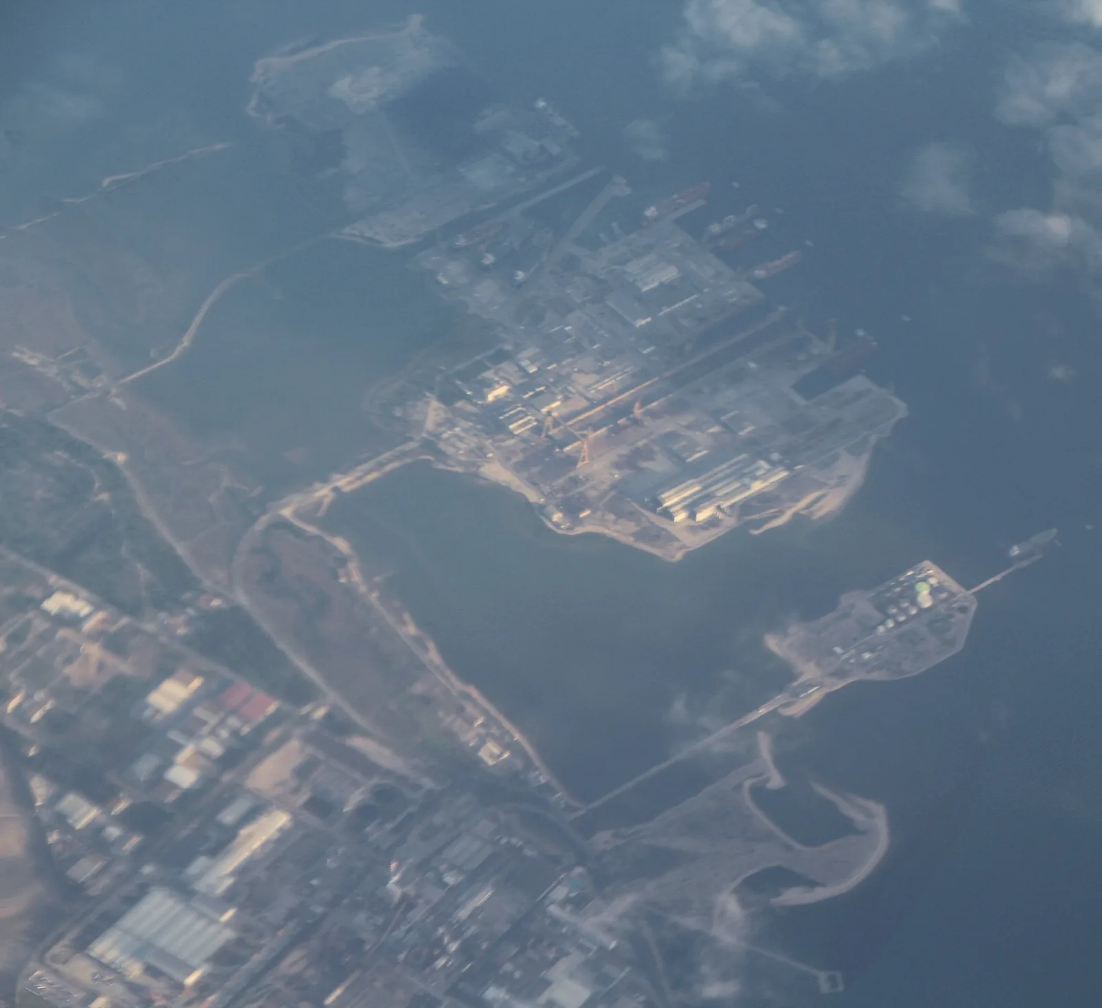
Industrial Core: Mitrena and Setenave
São Sebastião’s industrial zone, located in the Mitrena area on the banks of the Sado estuary, became a symbol of Setúbal’s industrialization. Here in the 1970s, the Setenave shipyards were established, becoming one of Portugal’s largest shipbuilding enterprises.
At their peak, the Setenave yards provided employment for thousands of São Sebastião residents and people from adjacent parishes, forming a working class that would later play a key role in the revolutionary events of 1974. Setenave workers were among the first to support the Carnation Revolution, and subsequent strikes at the shipyards became an important part of Portugal’s democratization.
After the shipbuilding industry crisis in the 1980s–1990s, the industrial zone was partially repurposed: parts of the territory are now occupied by logistics companies and warehouse complexes, though traces of the industrial era continue to define the landscape of this part of the parish.
Neighborhoods: A Mosaic of Social History
The Freguesia de São Sebastião comprises numerous neighborhoods, each with its own history and character:
- Bela Vista — a mass housing district, one of the most densely populated quarters in the parish.
- Manteigadas — a residential quarter known for its strong sense of community and active residents’ association.
- São Domingos — a district combining residential and commercial functions.
- Bairro Humberto Delgado — a quarter named after the general who opposed the Estado Novo regime.
- Terroa — one of the older districts on the parish outskirts.
- Monte Belo Norte and Sul — twin quarters on elevated ground, divided by the main road.
Each of these neighborhoods was built in different decades and for different social groups, creating a mosaic in which one can read the entire social history of Setúbal’s second half of the 20th century.
Social Housing: From SAAL to NBNC
São Sebastião became the arena for two large-scale housing programs that transformed the parish’s landscape.
The SAAL Program: Casal das Figueiras
After the Carnation Revolution of 1974, one of the most celebrated projects of the SAAL program was realized in São Sebastião — the Casal das Figueiras housing complex. This project, born from grassroots self-organization of former slum dwellers, became a model of the participatory approach to housing construction: future residents participated in the design and building of their own homes.
Casal das Figueiras remains a monument to the revolutionary enthusiasm of the 1970s — a period when it seemed possible to build not just housing, but a new society.
The NBNC Program
In the early 21st century, the parish became the site for the NBNC (Novo Bairro, Novo Conceito — “New Neighborhood, New Concept”) program, aimed at renovating deteriorated social housing estates. The program covers five areas in São Sebastião: Alameda das Palmeiras, Bela Vista, Forte da Bela Vista, Manteigadas, and Quinta de Santo António.
The program’s scale is impressive: 155 buildings and 1,655 housing units are slated for renovation or complete rebuilding. NBNC represents an attempt not merely to update the housing stock, but to reimagine urban space — with improved public areas, green spaces, and social infrastructure.
Educational Center: The Polytechnic Institute
The campus of the Instituto Politécnico de Setúbal (IPS) — the city’s largest institution of higher education — is located within São Sebastião. Founded in 1979, IPS encompasses schools of education, technology, business and administration, and health.
The institute’s presence significantly influences the parish’s character: thousands of students rent housing in surrounding neighborhoods, supporting local commerce and infusing the area with youthful energy. Around the campus, a student-life infrastructure has formed — affordable cafes, copy centers, bookshops — giving São Sebastião a university flavor atypical for an industrial district.
Commerce and Modern Infrastructure
São Sebastião serves as Setúbal’s commercial pole, an alternative to the historic center. Major shopping centers and supermarkets here attract buyers from across the municipality. Ample parking areas and convenient access via main highways make the parish’s commercial establishments particularly attractive to car-owning families.
Along the main transport arteries — primarily Avenida 5 de Outubro and roads connecting to the industrial zone — auto repair shops, building supply stores, and wholesale warehouses have established themselves, forming the typical landscape of suburban commerce.
Contemporary Challenges and Identity
São Sebastião’s central challenge is finding its own identity beyond the purely functional role of a “working-class district.” A parish that grew as a service territory for industry is searching for new meaning in an era of deindustrialization.
The NBNC program, the development of the Polytechnic Institute, and the gradual conversion of former industrial sites into zones of new use offer hope that São Sebastião can transform from a dormitory periphery into a fully-fledged urban territory with its own cultural life, public spaces, and sense of place.
Nevertheless, it is in this parish that Setúbal’s social stratification is most keenly felt: neighborhoods of comfortable homeowners adjoin social housing estates, and student youth live side by side with retired shipyard workers who remember both the revolution and the crisis.

📷 Image credit
Photo: Gazilion / Wikimedia Commons / CC0
See Also
- Social Housing and the SAAL Program
- The Carnation Revolution in Setúbal
- Canning Industry of Setúbal
- Modern Setúbal
All our knowledge is free. Creating it is not.
☕ Support on Ko-fi