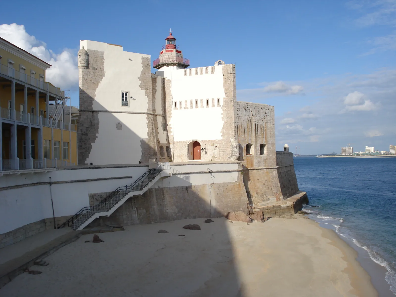
The Outão Lighthouse
The Outão Lighthouse (Farol do Outão) is one of Portugal’s oldest navigational lights, marking the entrance to the Sado River estuary and the port of Setúbal. Built in 1775 by decree of the Marquis of Pombal, the lighthouse stands within the walls of the Forte de Santiago do Outão – a bastion whose history dates back to the 14th century.
History of the navigational light
Watchtower (1390)
The first structure on the site of the present lighthouse was a watchtower (atalaia) erected by order of King João I in 1390 to observe the mouth of the River Sado. The tower warned the city of approaching enemy ships.
In 1625, during the Philippine dynasty, officers of the Casa do Corpo Santo – Setúbal’s principal maritime institution – petitioned the monarch to install a navigational light at the fortress to assist shipping.
Construction of the lighthouse (1775)
The lighthouse was built and first lit in 1775 by decree of the Marquis of Pombal. It was originally installed higher up the Serra da Arrábida slope, not at its present location.
The optical system was catoptric (metallic reflector-based), typical of 18th-century lighthouses.
Upgrades
| Year | Event |
|---|---|
| 1775 | Original installation on Serra da Arrábida (catoptric system) |
| 1857 | Reflector replaced with a Fresnel lens – the second Fresnel installation in Portugal |
| 1863 | Lighthouse relocated to its present site – Forte de Santiago do Outão |
| 1916–1918 | Lighthouse extinguished during World War I |
| 1917 | 4th-order Fresnel lens installed; oil lamp, fixed white light |
| 1954 | Electrification (220 V, 250 W lamp); light changed from white to red |
| 1982 | Keepers withdrawn; maintenance transferred to Direção de Faróis headquarters |
| 1984 | Full automation |
Technical specifications
| Parameter | Value |
|---|---|
| Tower type | Hexagonal with lantern and double balcony |
| Tower height | 11 metres |
| Focal plane height | 34 metres above mean sea level |
| Colour scheme | Lower section – white; upper section – natural stone; lantern – red |
| Optics | Fixed 4th-order Fresnel lens (since 1917) |
| Light character | Oc R 6s – occulting red, 6-second period (4 s on, 2 s off) |
| Range | 12 nautical miles (~22 km) |
| Admiralty Number | D2150 |
| ARLHS ID | POR033 |
Navigational role
The Outão Lighthouse marks the right (northern) bank of the entrance to the Sado River estuary. Its red light informs mariners of the approach direction to the port of Setúbal.
The lighthouse works in tandem with the Farol da Azeda on the opposite (southern) bank of the river – together they form the navigational reference system for the estuary entrance.
Forte de Santiago do Outão
The lighthouse is physically located within the fortress of Forte de Santiago do Outão, on one of its bastions.
History of the fortress
- 1390 – watchtower (João I)
- 1572 – expanded into a fortress by architect Afonso Álvares under Sebastião I
- 1643+ – upgraded under João IV after the Restoration to strengthen the port entrance defences
- Classified as an Imóvel de Interesse Público (Decree No. 129/77)
The fortress as a hospital
From 1890, the fortress served as a summer palace for King Carlos I. In 1900, a tuberculosis sanatorium was opened here. Since 1909, it has housed the Hospital Ortopédico Sant’Iago do Outão – an orthopaedic hospital that operates to this day.
It is this hospital function that restricts public access to the lighthouse.
Connection to the Fort of São Filipe
The Outão Lighthouse and Fort São Filipe formed an integrated defence system for the Sado estuary mouth:
- Outão controlled the entrance at sea level (right bank)
- São Filipe commanded the city and waters from above
Together, the fortresses provided crossfire against any hostile vessel attempting to enter the port.
Administration
The lighthouse is managed by the Direção de Faróis (DF) – the Lighthouse Directorate, part of the Autoridade Marítima Nacional (AMN) – Portugal’s National Maritime Authority. The DF was established in 1924.
Practical information
- Coordinates: 38°29'18.6" N, 8°56'3.5" W
- Location: within Forte de Santiago do Outão, right bank of the Sado estuary mouth
- Access: restricted (active hospital grounds)
- Lighthouse active: yes, automated since 1984
See also
Image sources
- forte-outao-lighthouse.webp — Forte do Outão with lighthouse, Setúbal. Author: GualdimG. License: CC BY-SA 4.0. Source
All our knowledge is free. Creating it is not.
☕ Support on Ko-fi