Underground Setúbal: Archaeology Beneath Your Feet
📷 Image credit
Photo: Semsjp / Wikimedia Commons / Public Domain
Beneath modern-day Setúbal lie 14 Roman fish-salting tanks from the 1st century, medieval walls with 5 gates and 13 posterns, tunnels under the Fort of São Filipe, and underground pipes from a 15th-century aqueduct. Every renovation in the historic centre is a chance to uncover another layer of 2,000 years of history.
Roman Setúbal: Caetobriga
Caetobriga (also Cetobriga/Cetóbrica) was the Roman settlement on the site of present-day Setúbal — an industrial centre for fish salting and garum production. It covered approximately 2.5 hectares, encompassing Largo da Misericórdia, the streets of Caldeireiros, Paula Borba, Januário da Silva, and Largo da Ribeira Velha.
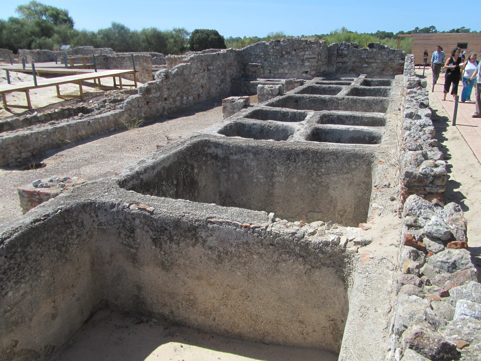
The factory on Travessa de Frei Gaspar
Discovered in 1979 during construction work. Excavations revealed two layers:
- Residential structures from the mid-1st century AD (peristyle, courtyard)
- A fish-salting factory from the last quarter of the 1st century with 14 tanks (cetariae) of various sizes, arranged in two parallel rows around a courtyard
The factory operated until the 5th–6th century. It is now accessible through a glass floor in the tourist office building.
The factory at Praça do Bocage
Excavations in 1957 and 1980 (led by MAEDS) uncovered a beach strip from the first half of the 1st century and a salting workshop from the second half of the 1st century with two types of tanks: those coated with lime mortar (for salt) and those with clay-sealed bottoms.
Roman mosaics
- Rua António Joaquim Granjo, 19 (“Casa dos Mosaicos”) — the first Roman mosaics found in Setúbal
- Rua Arronches Junqueiro, 73-75 — a porticoed gallery with an opus tessellatum mosaic floor, probably part of the peristyle of a Roman domus
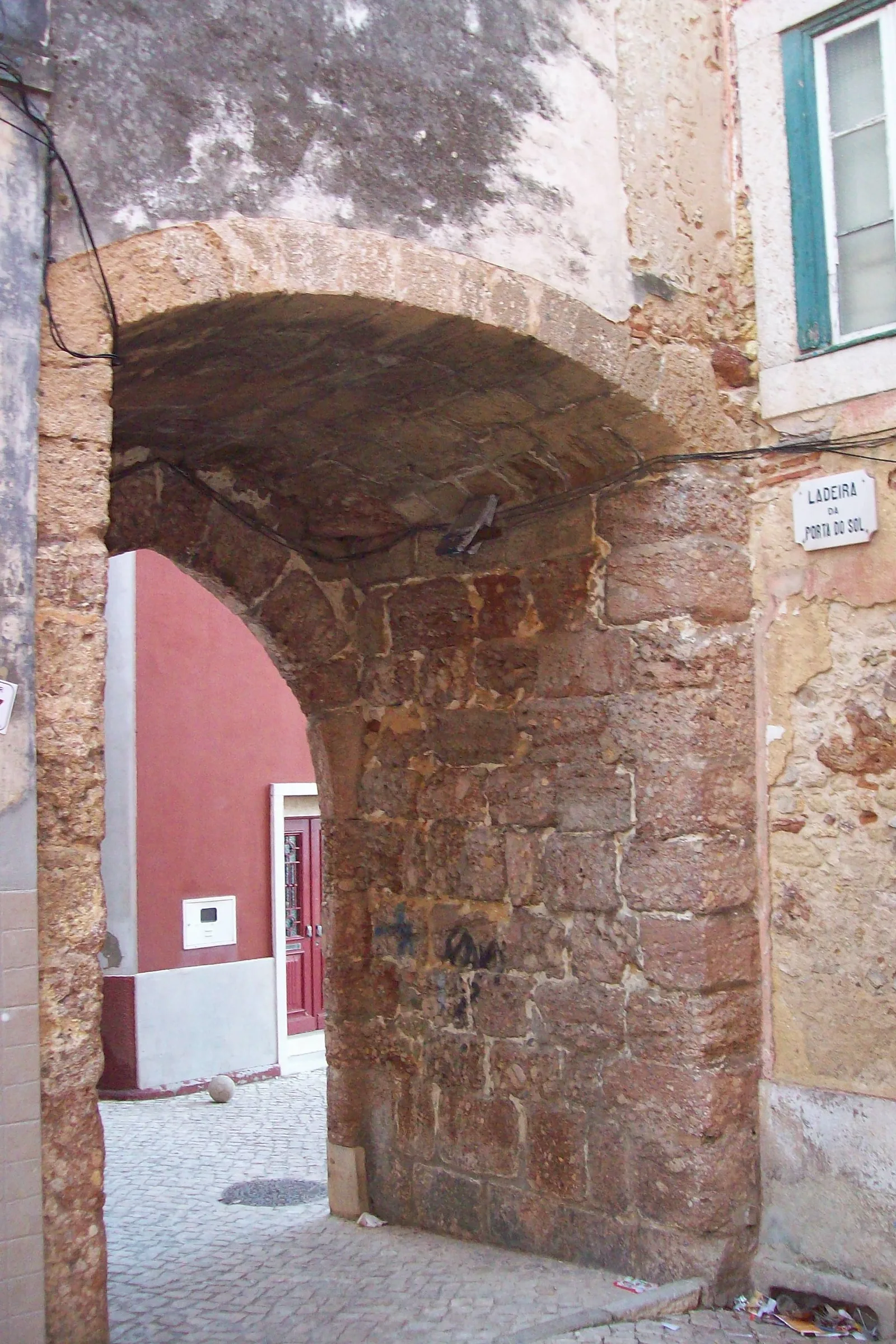
The medieval walls
Setúbal’s fortifications were built between the 14th and 16th centuries. The first enclosure was begun under King Afonso IV (1325–1357) and completed under Pedro I (1356–1367) — to protect against pirates and corsairs from North Africa.
The original perimeter included 5 gates and 13 posterns:
| Feature | Description |
|---|---|
| Porta do Sol | Pointed arch, 16th century |
| Porta de São Sebastião | Basket-handle arch with projecting voussoirs |
| Postern of Cais | Lowered arch |
| Postern of João Galo (das Fontaínhas) | Lowered arch |
Square and hexagonal towers are partly embedded in modern buildings and hidden under plaster. Archaeologist Carlos Tavares da Silva notes that unlike Elvas or Valença do Minho, Setúbal’s walls have “disappeared from the map”. They are classified as a Monument of Public Interest.
The tunnels of Fort São Filipe
Forte de São Filipe (construction from 1582, designed by Captain Fratino):
- A labyrinth of underground tunnels, normally closed to the public
- Entry through a gate in the western wall → stone vaulted tunnel → gentle staircase in two flights → landing with access to casemates
- A documented underground passage for possible escape from the fortress (during Spanish rule)
- In 2014, stabilisation work was carried out on the underground galleries: metal supports, crack sealing, waterproofing
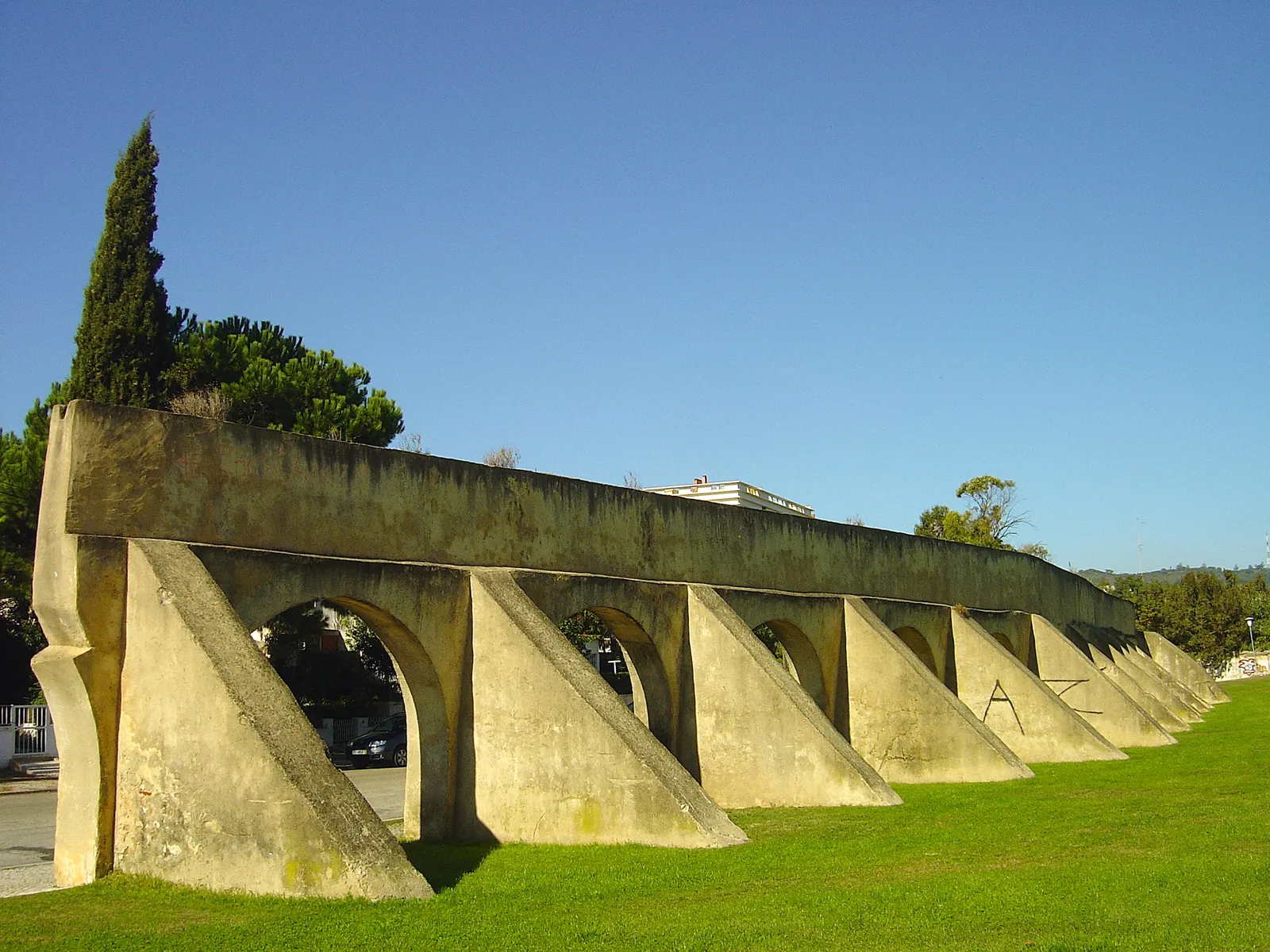
The Alferrara Aqueduct
In 1487, King João II ordered an aqueduct to bring water from the Alferrara spring (Serra de Palmela) to Setúbal.
- Length: several kilometres
- Construction: stone masonry to the city limits; underground pipes within the city to the fountains
- Terminal point: Chafariz do Sapal (built 1693, rebuilt 1697 in white and pink marble)
- 1894 — an artesian well at Campo do Bonfim (9.5 m high, 5 m diameter) to compensate for water shortages
Two sections of the aqueduct survive: from Rua dos Arcos to Bairro do Montalvão, some with double-tiered arcades.
The 1755 earthquake
Excavations at Av. Luísa Todi, 170-178 revealed an underground storage structure (cave) buried under debris from a 17th–18th-century residential building that collapsed in the earthquake. Since 2004, the sub-project “Earthquakes and Urban Archaeology” has been studying seismic traces in the urban underground.
The “Preexistências de Setúbal” project
A systematic urban archaeology research project run by MAEDS (Museum of Archaeology and Ethnography of the District of Setúbal, founded 1974). Key excavations:
| Address | Finds | Period |
|---|---|---|
| Rua Vasco Soveral, 8-12 (2018) | Stratigraphy from the Iron Age to the Modern period | 7th c. BC – 19th c. |
| Rua Arronches Junqueiro, 73-75 | Peristyle, mosaic floor | 1st–4th c. AD |
| Rua A. J. Granjo, 19 | First Roman mosaics in Setúbal | Roman period |
| Av. Luísa Todi, 170-178 | Underground storage, 1755 earthquake | 17th–18th c. |
| Largo de Jesus (2018–2020) | Funerary epigraph from the 12th century | Pre-monastery |
MAEDS publishes the journal “Setúbal Arqueológica” since 1975 — the key publication for the region’s archaeology. Lead researcher: Carlos Tavares da Silva.
The crypt of the Monastery of Jesus
The monastery was founded on 17 August 1490 at the initiative of Justa Rodrigues Pereira, wet nurse to King Manuel I. Architect: Diogo de Boitaca. The foundress and her family are buried in the crypt beneath the main altar. During the requalification of Largo de Jesus (2018–2020), a funerary epigraph from the second half of the 12th century was discovered — an artefact predating the monastery by 300 years.
📷 Image credit
Photo: Vitor Oliveira / Wikimedia Commons / CC BY-SA 4.0
📷 Image credit
Photo: Vitor Oliveira / Wikimedia Commons / CC BY 2.0
See also
The light is on for free. But someone has to clean the lantern.
☕ Support on Ko-fi